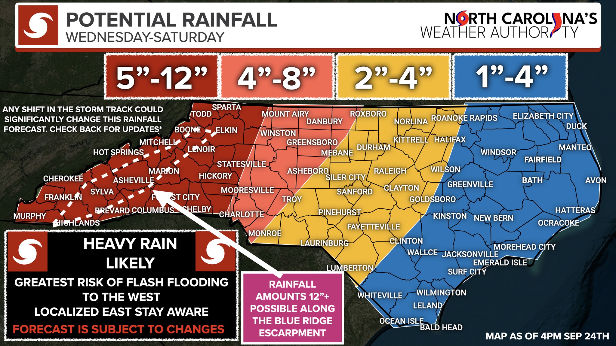
WNC Potential for Heavy Rainfall, Flash Flooding
North Carolina -- September 24, 2024: Heavy Rainfall: Here comes more rain, as if we need any more. There are still many
moving parts with the forecast regarding Tropical Storm Helene; regardless, there is a growing risk of significant rainfall across parts of the state Wednesday-Saturday morning, with the greatest chances of heavy rainfall late Wednesday across the mountains into Thursday and Friday; rain will start to pile up, I am becoming increasingly worried about heavy rainfall and Flash Flooding for areas west of Greensboro into the mountains later this week.
I have created a rainfall map using all the data available and my knowledge from past events. This map is effective starting tomorrow through Saturday morning; it does not include the scattered thunderstorms today that could produce heavy rainfall. I'll break it down; the bottom line is that the potential of Flash Flooding, landslides, and River flooding is increasing across parts of the foothills and mountains.
SECTION BY SECTION:
5-12 inches (Red): In the mountains and foothills, waves of rain will likely occur, with a Precursor Rainfall event likely Thursday before the main rain from Helene moves in Friday, as a stalled frontal boundary will be around. I expect 5-12 inches of rain through Saturday, with locally higher amounts of 12+ inches along the Blue Ridge Escarpment; as rain begins to pill up, we can expect Flash Flooding across this year. Landslides are possible, along with the potential for river/creek flooding. The greatest risk of this would be Thursday night and Friday. Now is a great time to clean out gutters and make sure culverts and other drainage areas are prepared. Be prepared to evacuate and move to higher ground if you live in a location that normally floods.
4-8 inches (Orange): I expect a few inches of rain across this area, with the best chance Thursday night into Friday; some localized Flash Flooding is possible in spots that normally flood first. (Higher Uncertainty here, so keep checking back)
2-4 inches (Yellow): I expect a few inches of rain across this area, with the best chance Thursday night into Friday; some localized Flash Flooding is possible in spots that normally flood first. (Higher Uncertainty here, so keep checking back)
1-4 inches (Blue) I expect some rain here; with the best chances of widespread rain on Friday some locally higher amounts can't be ruled out. We will need to monitor areas that have seen significant rainfall over the past few days, especially Brunswick and New Hanover Counties, for changes to the forecast and some renewed flooding concerns.
The Bottom Line: There is a significant risk of rain across parts of the state; we could see Flash Flooding over the next few days possible at any time across the Mountains and Foothills/ parts of Central NC, but highest Thursday into Friday. Right now, Eastern NC appears to be the see the lowest amount of rainfall, but we will continue to monitor track trends over the next 72 hours. I am posting this as an early heads-up. Don't take the numbers literally; I'm just trying to keep folks aware of the potential for heavy rainfall. I'll keep you posted as there are a lot of moving parts, but I believe in being real with you and telling you what I see without the fluff. Western NC, I am worried about this much rain. Hopefully, the forecast busts!
-Ethan
The above information was posted on social media by North Carolina's Weather Authority. Click the following link to go directly to their website: ncwxauthority.com --WNCTimes
Image Credit: North Carolinas Weather Authority


 How to resolve AdBlock issue?